


Yhteystiedot
Ammattilehti.fi
Vironkatu 9, 00170 Helsinki
www.ammattilehti.fi
Janne Jokela
janne.jokela@ammattilehti.fi
050 412 9030
Taneli Jokela
taneli.jokela@ammattilehti.fi
050 320 8174
Tero Lahtinen
tero.lahtinen@ammattilehti.fi
050 464 7972


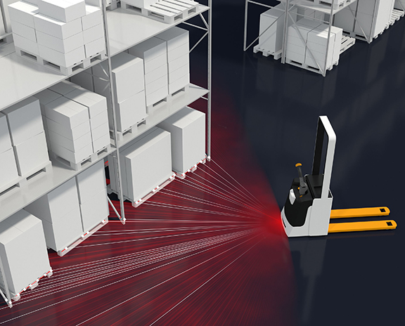
Precise orientation in factory and warehouse environments27.02.2019 11.01
Bosch Rexroth’s laser localization software determines the exact position of all types of vehicles in a factory 50 times per second, without the need for extra structural measures. As a component for self-driving vehicles, forklifts or milk runs, it generates dynamic maps of the deployment area. Thus, the software allows for autonomous navigation on mobile platforms. The movement data obtained from controlled vehicles can also be used to optimize fleet management. No floor markings, mirrors or other structural work in factories are needed for mapping. The position of vehicles equipped with this system can be determined with an accuracy of up to one centimeter within the factory. The software automatically detects changes in the environment and updates the map dynamically. Depending on the particular application, it then shares the map updates with a server or with the other vehicles in the fleet. The laser localization software requires minimal computing resources. It supports a wide range of popular control devices for autonomous vehicles as well as numerous laser scanners including safety laser scanners. Vehicle manufacturers can easily integrate the localization software into existing systems. Reliable localization is a requirement of autonomous vehicles in order to navigate safely in production and warehouse environments. It is already used in series production for the autonomously driving ActiveShuttle by Rexroth performing transportation tasks within the company. This precise localization can also be used as a basis for data-driven services assessing capacity utilization, planning routes or making further improvements to fleet management. The localization function is designed for demanding environments in production and logistics sites and allows for continuous as well as robust operation. |